A forecast timeline from AccuWeather shows that the next two tropical storms of the 2025 Atlantic hurricane season could form as soon as this weekend.
Why It Matters
Hurricane Erin was the fifth named storm of the season. As of Thursday afternoon, the storm is still a Category 2 hurricane with maximum sustained wind speeds of 100 mph. Its path is taking it away from the U.S., after, for the past few days, the storm has skirted the East Coast and caused dangerous waves and life-threatening rip currents.
In addition to tracking Erin, meteorologists are also monitoring several other disturbances in the Atlantic Ocean, two of which could strengthen into tropical storms this weekend.
What to Know
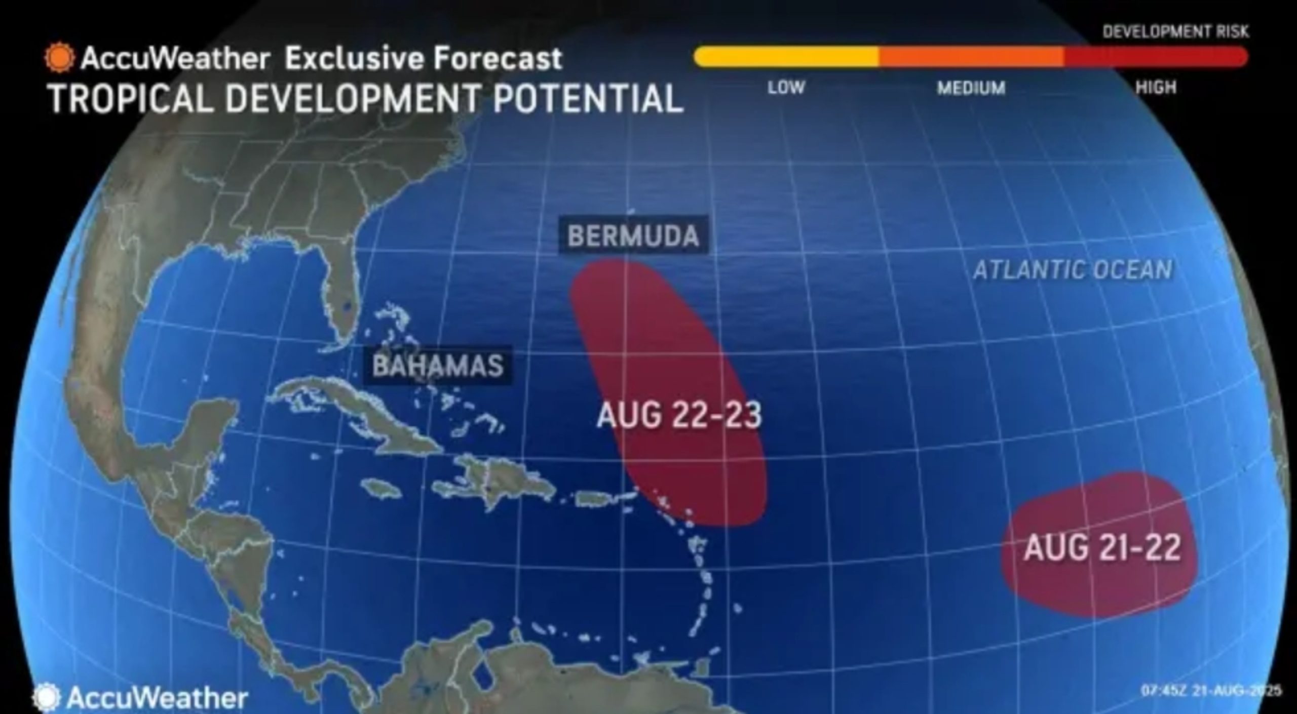
Both disturbances originated as tropical waves off the western coast of Africa. They have been traveling west across the Atlantic Ocean this week, with each day bringing increasing chances that the waves will strengthen into tropical storms.
In a Thursday report, AccuWeather meteorologists labeled both storms as having a high risk of developing into a tropical depression. One disturbance is located near the Leeward Islands in the tropical Atlantic, and the other is in the eastern tropical Atlantic.

AccuWeather
The storm closer to the Leeward Islands is expected to follow a path similar to Hurricane Erin, AccuWeather Lead Hurricane Expert Alex DaSilva said in the report. This storm could strengthen into a tropical depression between August 22 and 23, according to AccuWeather’s timeline.
“The good news is this does not look like a threat to the United States at all … at least for direct impacts,” DaSilva told Newsweek, adding that if the storm becomes a hurricane, it could cause some large waves and rip currents along the East Coast, though not as severe as those that were generated from Hurricane Erin.
Meanwhile, the disturbance in the eastern tropical Atlantic could form between August 21 and 22, according to AccuWeather’s timeline. If it doesn’t, DaSilva told Newsweek that environmental conditions could make it fall apart.
The National Hurricane Center (NHC) is also monitoring both systems. The NHC lists the disturbance closer to the Leeward Islands as having a 50 percent chance of forming in the next 48 hours and a 70 percent chance of doing so in the next seven days. The disturbance in the eastern tropical Atlantic has a 40 percent chance of forming within the next 48 hours and equal chances of doing so in the next seven days, according to the NHC.
What People Are Saying
DaSilva said in an AccuWeather report: “The tropical wave in the middle of the Atlantic Ocean is expected to follow a similar path to Erin. However, sea surface temperatures may have been temporarily cooled in Erin’s wake, which could inhibit rapid development early on.
“The tropical wave just west of the Cabo Verde Islands is expected to track farther south than Erin and move over warmer waters. However, as it nears the eastern Caribbean islands, it may encounter disruptive upper-level winds that could inhibit further development.”
What Happens Next
Dangerous ocean conditions will persist along parts of the East Coast through the end of this week as Hurricane Erin moves further out to sea. Meanwhile, meteorologists will continue monitoring the disturbances in the Atlantic.