Millions of Americans across several states are facing the risk of severe storms on Thursday, according to forecasters.
Why It Matters
Meteorologists say the potential hazards posed by the storms include heavy rain, hail, and even tornadoes, which can cause widespread disruption and hazards.
What To Know
“Severe thunderstorms capable of large hail, damaging winds, and perhaps a couple of tornadoes are possible late this afternoon into tonight across parts of the central Great Plains to the Midwest,” the NWS Storm Prediction Center (SPC) said in its outlook for Thursday. “Additional severe storms are expected across parts of the Northeast and Southeast,” it added.

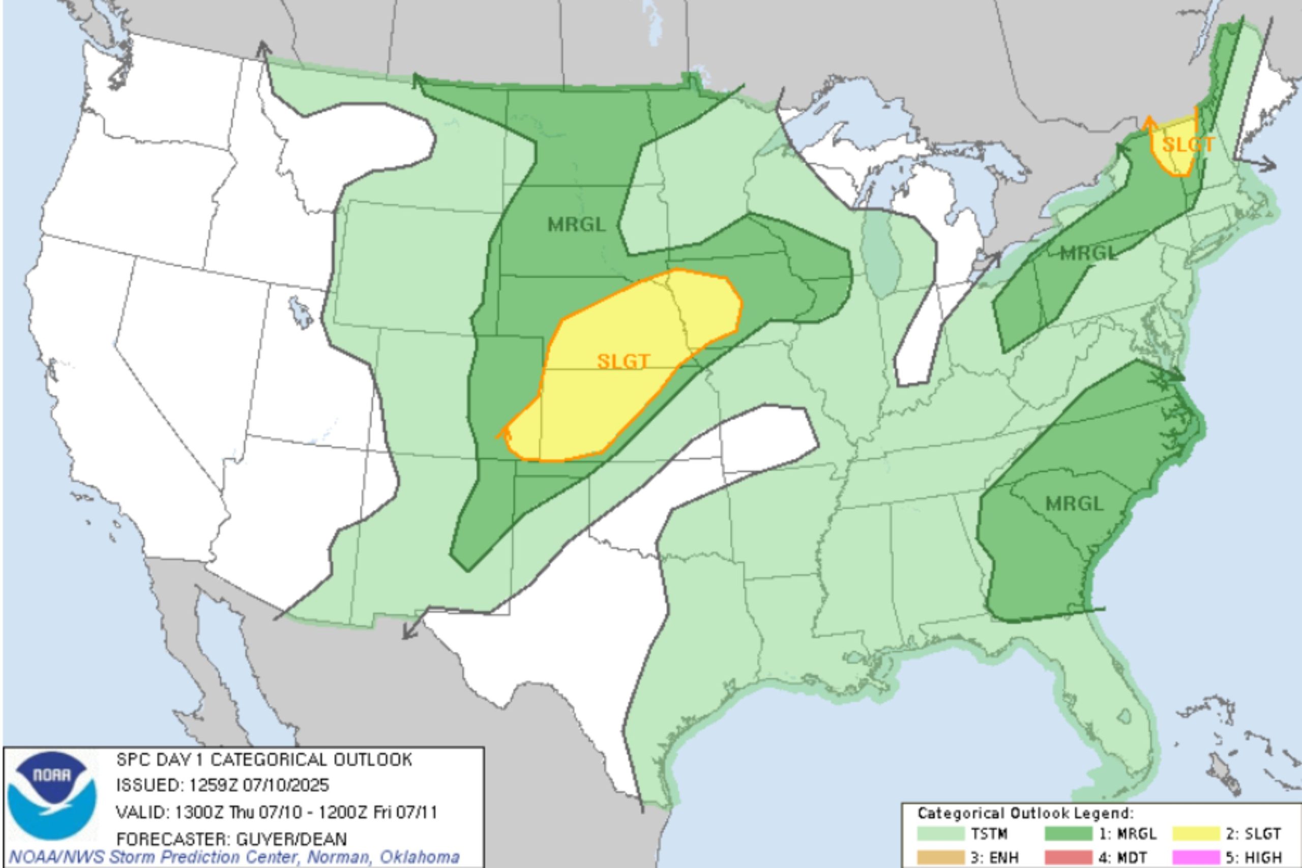
Storm Prediction Center
According to a forecast map from the agency, western Iowa, southwestern Colorado, as well as large portions of Nebraska and Kansas were in the highest risk area.
In the northeast, parts of Vermont and northern New York also faced higher risk.
The highest-risk zone spanned approximately 130,000 square miles and encompassed almost four million people, according to the SPC.
AccuWeather meteorologist Chad Merrill told Newsweek that Fargo and Sioux Falls in South Dakota, as well as and Lincoln, Nebraska, face a moderate chance of severe thunderstorms from this Thursday afternoon into Thursday night.
Des Moines, Iowa, Bismarck, North Dakota, and Rapid City, South Dakota, are also at risk for severe storms today, Merrill said. Merrill said primary threats include hail, isolated tornadoes and flooding downpours.
“There could be a few minor travel disruptions due to the storms. The storms will linger the latest into the night across Iowa into far western Illinois (along and north of I-80),” Merrill added.
What People Are Saying
The NWS forecast office, Des Moines, Iowa said on X, Thursday: “Several rounds of storms are forecast late tonight through Fri with heavy rain expected, especially during the overnight hours. Rainfall amounts of 1-3″ are likely into Fri AM with higher amounts possible. River rises are likely with flash flooding possible mainly in urban areas.”
It added: “Additional severe weather chances are forecast on Thurs & Friday afternoons into evenings. The primary threats both days are damaging winds & heavy rain, but a tornado is possible on Thurs PM. Continue to monitor the forecast for updates as threats and location may change!”
NWS Burlington, Vermont, said on X, Thursday: “Showers and thunderstorms are likely this afternoon. Showers will develop off the Greens around noon and drift eastward across Vermont with additional chances in northern New York and the Champlain Valley. The main concern will be heavy rain and localized flash flooding.”
What Happens Next
Forecasts are sometimes subject to change. Agencies such as the National Weather Service issue regular updates.